

The Futa road over time
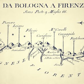
Records attest to the existence of importance settlements on the right side of the Savena river (San Ruffillo, Loiano, Monghidoro) after 1000 AD and in this period a route largely corresponding to the Strada della Futa was established along the ridge to the right of the Savena.
In the 12th century it was defined as a "mountain" road and in official documents it was "Strata qua itur Florenciam" (road to go to Florence). Starting from the second half of the 13th century, the City of Bologna chose this road as the official trade route to Florence and in 1246 had a castle-fortress built in Scaricalasino to defend its territory.
In 1300, on the occasion of the Jubilee, the "Via di Toscana" (Tuscan Way), whose starting point was the Abbey of Santo Stefano in Bologna, was recommended to pilgrims travelling from the north toward Rome. The road was little more than a mule track in that period. In the 16th century, there were establishments serving refreshments, hospitalia (shelters for travellers), and staging inns for changing horses in Pianoro, Loiano, Anconella and Scaricalasino ("unload the donkey", the present-day Monghidoro, where transported goods were unloaded from pack animals for border inspections).
There are no records of major changes until the 18th century, when the grand duke Francis of Lorraine decided to transform it into a carriageable road in order to facilitate travel between Florence and Vienna, (his wife Maria Theresa was the daughter of the emperor of Austria). His plan was opposed by the papacy, which aimed to develop a link to Rome within papal territories, via Ancona and Loreto.
Until the first half of the 18th century, the road was carriageable up to Pianoro, after which it was a "road for saddle animals and carts". In the mid 18th century, on the initiative of the Lorraine family, a new shorter route was designed, which entailed abandoning the Giogo pass for the higher Futa pass (from which the road would take its name). Travel times between Bologna and Florence were reduced to between 12 and 15 hours.
During the Napoleonic period, this road was included in imperial highway 6, which went from Paris to Naples. Napoleon was unduly blamed for the "cut" which eliminated another large stretch of roadway in Livergnano between 1817 and 1820. No substantial changes occurred for nearly the whole of the 19th century. Some major variants were introduced at the start of the 20th century, above all to limit the steepest stretches.
The "Futa" then became legendary thanks to automobiles and the famous "Mille Miglia" ("Thousand Miles") race, held for the first time in March 1927. In 1944-45 war operations aimed at breaching the Gothic Line wiped out historical buildings and seriously damaged some towns situated along the road. In the post-war period, the "Futa" was reborn, with a strong emphasis on tourism and culture, after the flow of automobile traffic had been diverted to the Apennine stretch of the Autostrada del Sole (1960).
Why the name? The road has been routed through the Futa pass only since 1752. Before then, it crossed the Tuscan Apennines at the Giogo pass, touching Firenzuola and Scarperia. The Futa pass is exposed to the often impetuous winds of Romagna (la rumagnola, l'óra, la tramontana) and milder western winds: the mountain chain splits open here and the winds hurl themselves against it.
Enough to overturn carriages and unseat people from their horses: we can read this in the travelogues of foreigners who visited Italy. Suitable shelter was provided by a wall that was built to the east of the pass (e muraión dla Futa) and is still today a landmark for tourists. In old Tuscan futa meant fuga, flight or escape (Dante, Purgatory, XXXII, 122): escape of winds or from winds? Perhaps this is the source of the toponym.